My dear cousin Sam, who’ll soon start featuring as an occasional guest photographer with us, asked what’s happened to my “Lake Living” series after viewing a recent post. As in, has it stopped being about lakes and started being about living on water. So herewith a few principles I’ve been working on for these “coasting” and “lake” categories. Because you might look at these photos and say “it’s not a coast, it’s a river.” Or you might look at the previous post that Sam questioned and say “that’s not a lake, it’s a bay!” But in our recent explorations here at smw, slt we’ve learned much more about water management & what what water connects to what other water, than we knew when first we got close enough to Zeeland to see the maeslantkering, which we featured in an earlier post.I’m proposing that a lake is a body of water that’s primarily fresh because it’s protected or cut off from the tidal flows that would come with extensive connection to an ocean. And that a “coast” is where a body of land that’s connected directly to a mainland-continent type landmass meets a body of water that’s close enough to the open ocean as to make nearly no difference. To whit,the city of Vlissingen, which is what you’re seeing here and which just happens to be the last stop for any train heading into the province of Zeeland from the rest of NL, is the only place south of the maeslantkering itself where the North Sea has free access to the interior of Zeeland. In other words, though Bergen Op Zoom – subject of that Lake Living post Sam queried may look on a map as though it connects by estuarial channels fairly directly to the North Sea, it in fact deliberately no longer does, due to all the massive water works NL did after the floods of the 1950s to build dams, dikes and the maeslantkering in order to protect as much of the interior as they could. If curious, please see a clear map in this link of all the many places where the North Sea’s access has been cut off by dikes and dams, which are now generally being upgraded to rise higher due to global warming and NL’s natural hope to remain an inhabited country despite American consumer’s addiction to gas-guzzling cars…and other carbon over-use issues. I’ll do one more explanation later on, when we get to the large body of water to the north and east of Amsterdam…which, until my visit two weeks ago to the castle so beautifully introduced in a recent post, I thought incorrectly was also salty & connected to the North Sea. But otherwise, assume these are my current working definitions of coast & lake…and ponder how global warming and Dutch ingenuity + determination give rise to interesting questions :-).
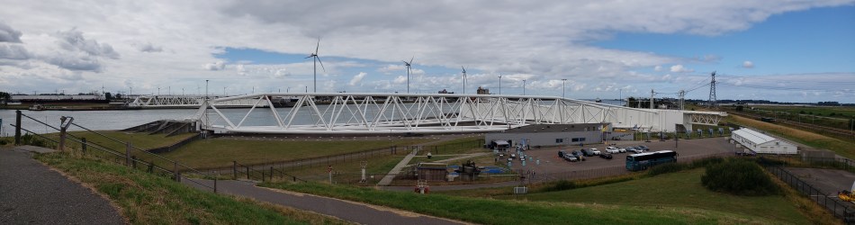
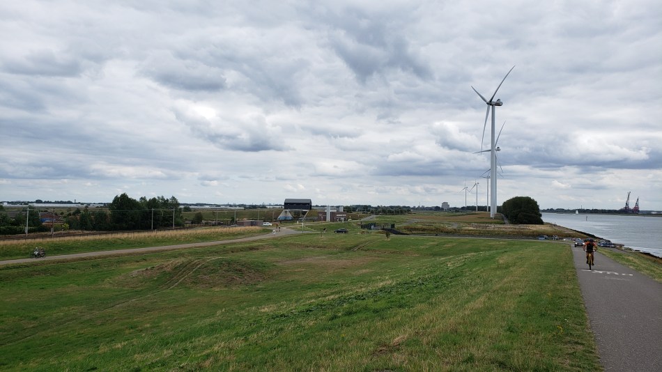
Behold one of the largest moving structures in the world: the maeslantkering. I figured this would make a suitable entry for the 100th time I’ve posted this city / urban canal series. (Turns out when I first started, just after moving here in July ’21, I was calling it City Canals, to counterbalance a series I hoped to start that I still call Country Canals….and then at some point without noticing I just morphed it into Urban Canals. Sorry…) Anyhoo: this is, I think, technically within the municipality of Rotterdam but as you see it’s heavily industrial, not residential or commercial. For more on those parts of Rotterdam, check out for example this post.) We’re within a kilometer or so of the Hook of Holland, where the largest channel of the Rhine Delta meets the North Sea, and this large white structure is a movable storm-surge barrier intended to protect the city and inner port of Rotterdam. The outer port, where the hugest container ships dock, is behind the windmills you see in the panoramic photo just above, on south side of the river, in the Europoort Rotterdam and the Maasvlakte Rotterdam. I’ve bothered to learn all this partly because I’m just a geek and it fascinates me what the Dutch do with water and rivers, and partly because I read Neal Stephenson’s latest speculative-fiction novel during my multi-week visit to Myanmar, so when I landed back in NL and the guy I’m currently stepping out with suggested we drive the beach somewhere, I said “let’s go see the Maeslantkering!” (He has a car, I don’t, and really the best way to get there from A’dam is in fact by car, although there are public transit and bike methods, this being NL, after all…) And just to give you more sense of the general surroundings (good example of Dutch urban planning, what with artificial mountain-bike courses e.g. the small part below where I saw classes of kids being taught, canals, bike paths, etc. all snugged up against one of the largest ports and busiest shipping channels in the world), a bunch of other photos from the Hook of Holland and the immediate surroundings of the maeslanterking, below. (Yes, wiki has a nice piece about this structure for you fellow geeks out there. And yes, I finally donated today, recognizing that I’d be lost without wiki by this point.)
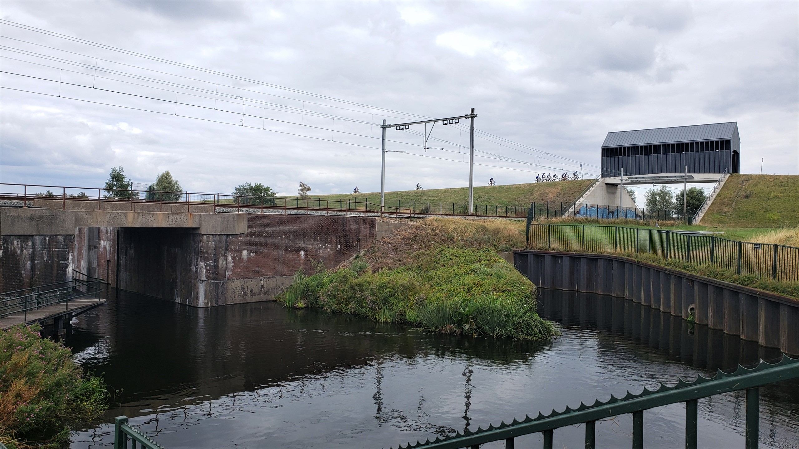
It’s my blog so I get to define what’s a “village” and what’s not. This is one of those uniquely Dutch views: railroad overpass covered-bridge which is mostly used by bikers, specifically small and large classes of kids taking mountain-biking classes on the natural and enhanced (since almost everything that touches upon elevation above or below sea level, flow of water and so on in NL are very much human-enhanced) hills and dunes and canals surrounding … the Maeslantkering, one of the world’s largest movable structures whose northern half sits perhaps 300 meters behind me as I took this photo on my first full day back from Myanmar. Photos of the Maeslantkering and other Hook-of-Holland area sites to come.