Walking The (Fire) Line in Annadel


The cal-fire site tells me that the Nuns fire complex ultimately burned 56,556 acres. The final report date on the site is November 6, which I suppose means it was 100% contained or fully extinguished on or before that date. Earlier, I’d assume, since the superintendent of Annadel State Park allowed parts of the park to reopen for hikers, bikers and runners on the 5th if I understood the signs well.
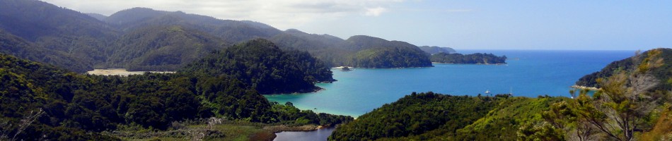
My last post contained all the photos I’d taken in Sonoma County between returning from Haiti (late April), and the day of the post. Today, I’m posting almost entirely photos taken yesterday in my beloved nearby State Park. Annadel is a gem on the eastern edge of Santa Rosa which has been a key source of recreation and mental-health management for me here in Santa Rosa. The fire burned through about 2/3 of it, and if the wonderful fire fighters (see thank you signs from my last post) hadn’t stopped it where they did, then it would have destroyed many homes near the park, and I guess there was a very real risk this fire complex would merge with the Tubbs complex, which had already destroyed so much to the north in Santa Rosa.
 With many of the trails open, I got out there again yesterday to appreciate the park and take stock of the damage. I try to find silver linings: that it WAS stopped here is a silver lining; that green shoots are already sprouting among the charred grasses is also good to see. (See the round gallery a little lower down.) The rainy season has come – it’s sprinkling as I type this – and so we must hope for enough rain to allow plants to re-grow strong…but not so much as to cause too many land slides in all the newly-vulnerable areas whose trees and grasses have been burned.
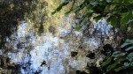
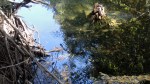
If you look closely, you will really see how rapidly the fire passed through (burned areas surrounding unburned patches), plus the stark line where they stopped the fire: trees charred on the south side, still green moss on the north side. Rocks the same way. Since I already wrote more in the last post, I’ll leave it here for now. Gratitude, shock, slow return to regular life, I guess. Peace, everyone. Most photos have titles that’ll tell you what they are or why I selected them.


Can you spot the photo in the gallery above is not taken in Anndel? It’s this entry’s tribute to our first-responders. 🙂

 In a post last year, I did a selfie while taking a breakfast break lying on one of these two tables, at the junction of Marsh & Canyon trails. Canyon was the fire line through this portion of the park — the photo above, here, with straw over where fire fighters had widened the line is on Canyon trial, west of this point. To compare then and now, check this link or others labeled Annadel, or Sonoma County, or Napa & Sonoma (I need to work on my tags…) — https://somuchworldsolittletime.com/2016/08/19/dry-hillsides-live-oaks/
Fall Foliage, Fire, Fear & Faith


For a lot of reasons, I tend to hide the personal me on this blog – focusing instead on the remarkable people I’ve worked with & places I’ve been. The personal me is by nature a fairly private individual, even if I occasionally manage public coherence when speaking about my work experiences. With this post, I’m making exceptions to a few of my usual rules: I’m taking photos out of order, so as to include photos taken this very morning (rather than continuing to work my way forward from late May, when I took those last photos I posted from Beacon, NY)…and it’s more than usually about me and the community I’ve called home since 2014.
The place I call home is Santa Rosa: county seat and geographic heart of Sonoma County, a lovely small city nestled between mountain ranges, surrounded by parks (state, city and county), blessed with farmers who plant and grow the most delicious fruits and vegetables and bring them to us at year-round farmer’s markets, with vineyards that produce fantastic wines, with so many breweries & brewpubs that it’s an embarrassment of riches. We’re blessed with bike paths, with urban planners who let the traffic lights notice the small profile of a biker as well as the larger profile of a car…meaning I can make a left turn without having to get off my bike and press for the walk signal at most intersections.
 …look closely in the photo above and you will see some blackened patches, not far from roofs of houses built up against the edge of the park on the lower slopes of those hills. I’ve had camera trouble (an SD card went haywire) so I had to re-do these photos with the wrong light and I can’t get back out there again soon when the light’s better…so, sorry for the lower quality of today’s photos.
Here in Santa Rosa I’ve been able to hop on my bike, take to the hills and work through whatever stress and sadness have accumulated through the work I do. I’ve grown accustomed to working in places which are in the headlines – a year ago, I was living in Port au Prince when hurricane Matthew struck; just two months ago, I was in Sierra Leone when a landslide & flood killed hundreds in an instant. I had not thought to have friends texting and writing to ask if I was safe at my home in Santa Rosa – but that’s what happened, Monday the 9th of October as I sat with my mother in a doctor’s office on the other side of the continent. First, friends called to ask if they could offer my apartment (empty, since I was away helping my mother with some medical challenges) to people suddenly evacuated because of the literal fire storm which with shocking speed consumed homes, lives, hotels, and businesses overnight from late on Sunday the 8th into the 9th. Then other friends began texting, to ask whether my own home was affected. And there I was, a few thousand miles away with other commitments.
I returned home six days ago, and have been taking stock of this city & county I’m so happy to call home and pay my taxes in…since, after all, it’s those wonderful county taxes which support our wonderful firefighters and responders, I assume. I’m offering here a range of photos, all taken between late April (when I returned after the end of my assignment in Haiti) and this morning. Each photo has a file name which will tell you what it is – and usually when it is. 171027 means this morning, 2017 – 10 – 27, and so on.


Since I have reading friends and followers around the world, let me explain a bit: California (especially the coastal parts, but really most of the state) gets all of its (limited) rain in the months from October to April. Usually it’s really November to March. Our plant and animal communities – from the famous redwood trees to our mountain lions and California poppies – have evolved around these extremes of wet and dry, with fire as a critical part of the ecostystem. Redwoods, I believe, thrive on flash fires – which clear away their competition in rapid brush fires which they can easily survive. Caveat: I’m not an expert on this stuff, but am trying to remember what I’ve read in park signs and articles. I’m quite certain that fire has been part of the native ecosystems here since long before even the first Native Americans arrived in what’s now Sonoma County – let alone before the first Europeans interlopers arrived just a handful of centuries ago, when most redwoods still standing were already mature.
The first photo in this post was taken in Annadel State Park in late April – at the end of the wettest rainy season we’ve seen in many years. Of course, that rain meant we had lots of new growth this year. And of course, we had our usual dry season which led to the brown hills with dusty green of scrub oaks and lots of dry new growth, which you’ll see in other posts. Look closely at the photo just below, and you’ll see how the grass burned on the hills of Annadel just above a city park where I often play tennis. It’s fairly common for parks to burn, this late in the dry season. It’s not at all common for a firestorm to erupt and spread so very rapidly under heavy winds. Friends who were here at the time, and who were evacuated, tell stories of going to bed aware of heavy winds, waking up to the sound of neighbors knocking on doors and/or loading their cars with family and pets then driving off, at 3 in the morning. I do not have the heart to show the destruction to property and homes: those photos are already out there, and for me to pile on feels disrespectful to the members of my adopted community who have lost so much. I am worried about one of my favorite farmers, who grows in the northern part of Santa Rosa where the first fires were at their most intense. (It’s her produce you see in one of the photo galleries further down – from figs to aubergine/eggplant and peppers.) I hope when I next make it to the farmer’s market, I’ll learn that she and her farm and family are all OK.


This is already a longer post than usual – and as you see, I’m throwing in a range of photos I’ve taken throughout Sonoma County since returning from Haiti in April. Why? I’ve been fearful about the health of people I love, from my mother to friends here in Santa Rosa, to a dear family friend who passed away last month. And I’ve certainly been fearful for the homes and lives of my community here – including my own home, which has remained untouched (knock wood) but was much too close for comfort.

At the same time I have been heartened, as always, by the magnificence of fall foliage both on the east coast (New York, New Jersey) and here in Santa Rosa. By the enduring refuge of nature and the cycles of our planet which so greatly outstrips my own small life and experience. I take comfort from understanding myself as one transient element of a planet and a universe I find beautiful and enduring, and which I hope future generations will enjoy long after my own molecules have reassembled elsewhere. I also remember that at most times, even in places affected by great crisis, most people are doing their best to get on with life, feeding their kids and wiping their noses. 


A thing I’ve loved about Santa Rosa & Sonoma county since first introducing myself here is how warm and friendly people are. This is reflected, I think, in the fact that I see signs everywhere thanking our first responders: the fire, police, emergency-response and support professionals who have deployed from communities near and far to limit damage, hold fires back from property and lives as much as possible, and help everyone react and adjust as well as we all can. I interpret this not only as gratitude that they’ve helped save so much, but also as refusal to give in to fear, insistence on seeing hope and opportunity rather than only loss or worry. These are, in the end, individual choices each of us must make: live in fear or live in hope? My favorite park is closed until further notice – but I’ve learned again how many of us love that park (see the sign with heart saying we love Anndell, noted on a fence not far from me). Being redirected to other bike paths and parts of town also helps me see and learn anew – for example, that our city has provided a fly-casting pond where folks walk their dogs and practice their fly-casting techniques for their next trip to the trout streams. So, despite a worried heart about people at risk or dealing with loss, both near and far…I find faith that the sun will rise again tomorrow, that we’ll find our way through these difficult patches, and that somehow we’ll rebuild and restore balance and harmony, first in our community and then, perhaps, elsewhere on a fractious globe. Peace, out.


Enjoying Beacon (NY)

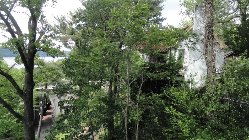
![]() Another thing our mother loves is art and exploration. Beacon, NY is a great place to visit whether for art, history, or views of the Hudson from its foot bridge park over the river. By car Beacon is the eastern terminus of the Newburgh-Beacon bridge across the Hudson. DIA Beacon is a fantastic contemporary art space in a repurposed factory of some sort or other, which we’ve visited a few times before; this time I brought out my camera in the rooms they told me I’m allowed to. I hope I’m allowed to post these here – if not then I guess I’ll have to drop this post since nearly everything was taken there. 😦 Its large rooms are full of very atmosperhic, immersive and thought-provoking or meditative work that I really enjoy.
Another thing our mother loves is art and exploration. Beacon, NY is a great place to visit whether for art, history, or views of the Hudson from its foot bridge park over the river. By car Beacon is the eastern terminus of the Newburgh-Beacon bridge across the Hudson. DIA Beacon is a fantastic contemporary art space in a repurposed factory of some sort or other, which we’ve visited a few times before; this time I brought out my camera in the rooms they told me I’m allowed to. I hope I’m allowed to post these here – if not then I guess I’ll have to drop this post since nearly everything was taken there. 😦 Its large rooms are full of very atmosperhic, immersive and thought-provoking or meditative work that I really enjoy. ![]()
We try to get out for art with Mom any chance we get (just browse through the index for other outdoor art we’ve enjoyed on a few continents — consider this post from nearly a decade ago: https://somuchworldsolittletime.com/2007/12/23/yorkshire-sculpture-park/) …and this was a good outing with her and my brother Steve. I’m still catching up with life – these photos were taken in late May, and in the interim much has happened, but we’ll slowly catch up and put the photos that seem interesting here. For now, I’m working from the motto “take pleasure in art, beauty and friends where you can.” May we all do so. 🙂

Springtime in the Park with Mom


When I returned from the two year assignment in Haiti, I landed first in a late Canadian winter/early Canadian spring, then came south to spend a week with my mother in New Jersey. A thing that’s changed since I was a youth here is more wildlife — time was when it was rare to see deer even in larger state parks; now they roam our little local streamside parks, where some of these photos were taken. So, as autumn advances in the northern hemisphere, a reminder of this spring and springs to come :-). Enjoy.


Bridges, Buildings & Skylines of NYC

 I’m back from a short assignment in Sierra Leone, furnished with a new computer and the renewed ability to get photos off both my camera and my phone and then edit them more or less as I like. So I’ll be trying to update my readers – be you known friends & family, or some of my many much-appreciated but unknown viewers from around the world – with all the various things I’ve been seeing and doing in recent months. A thing I’ve learned from my many MSF friends and colleagues is that, even for those who could afford the airplane flights to the US, the idea of visiting the US is very unappealing to many in the world. Either the active adventure travelers assume it’s a destination for one’s older age when the energy to hike and live rough is reduced…or many of my friends and colleagues are understandably concerned about the warmth and humanity of their reception in a country whose “elected” government has gone so bitter, angry, and unwelcoming. I find that a pity since there’s so much worth seeing in the US and also so many people of all backgrounds and perspectives, many or even most of them really quite lovely as individuals, even in states currently driven by the most angry and unwelcoming people. All but one of these photos were taken on the island of Manhattan, the heart of New York City, between April and June. The photo just below, in which my brother Steve & I join our old family friend Jill to celebrate my mother’s 81st birthday, was taken on the far side of the George Washington Bridge (see the slide show below), in New Jersey. Since the GWB is Mom’s favorite bridge in the world, the gallery is a small tribute to her also. Though I love my work and how it exposes me to the realities of a world beyond our shores here in North America…well, it’s always nice when I get back to my family, even if being here means living in denial about the fact that our classy, smart & cosmopolitan President Obama seems to have left the white house… As usual, captions will try to tell you what each photo is, and I’ll write nothing more but let you appreciate NYC and its architecture, skyline and hidden corners.


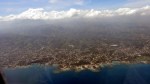
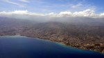
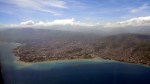
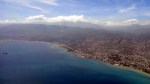
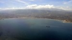
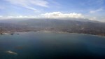
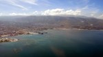
Spring -> Snow -> Beach – In the Air
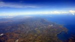
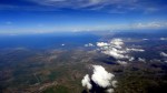
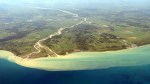
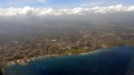
 After that last visit to Amsterdam, I flew home to California in late April, the end of a wonderfully wet and snowy rain season on the west coast: which meant lots of much-needed snow even in the mountains of California! As always, I aimed for a window seat and kept my camera handy. I no longer remember the precise route, but I think we went about 1/3 of the way up Greenland and across northern Canada, then angled down around the mountains between British Columbia & Calgary in Canada, and across into the US south of there still angling southwest. The four big photos (above, below, and after the gallery) are out of order — look closely and you’ll see the Hollywood sign on the hills in the photo of LA just above, as the plane flew inland then swung around and line up for the southern runway’s approach route. And I’m fairly sure the photo directly below is from Greenland. (Yes, a thing those from the East Coast of the US may not know is that when flying from the West Coast to Europe, one usually flies over Greenland, as opposed to just south of Iceland which I usually seem to do when flying from NYC.) The shots in the gallery are all in order. I think we crossed the Sierra Nevada south of Yosemite and I was seated as you see on the left of the plane, so I didn’t see Mt Whitney or Yosemite from the air, more’s the pity – the few times I have, my camera has not been handy. Oh well…next time :-). Enjoy!


It’s Raining in California!
 The bay area, which I call home and return to between assignments or even on vacations during an assignment when possible, has its icons. There the golden gate bridge, which I cross every time I go to my own physical home after flying into SFO. There’s the corner of Castro & Market, with its massive rainbow flag as a statement to the world that the city’s LGBTQI (did I forget any of the currently-accepted letters?) population is proud and not about to creep back into some box just because some people don’t much like us. There’s Mt Diablo, forming a triangle across the bay as the highest peak in the immediate bay area — visible behind that rainbow flag, down below. There are vineyards…and this year, there’s rain in the vineyards! And snow in the mountains, though I’ve not yet been to see it myself. Perhaps I’ll make it to the mountains after this assignment, before it all melts. Something to keep in mind.
In any case, I was recently back amongst these icons for a final vacation during the current assignment. When the weather was sufficiently clear, I walked or biked around and appreciated the greenest vistas I’ve seen in years, since California’s been in a drought that’s grown more severe year by year for a decade or so. As it rained on my way back to the airport for the flight back to PaP, I photographed one of Sonoma County’s lovely hillside vineyards through the bus’s rainy window. On the way up, I photographed the GGB through the bus’s reasonably clear window. And I took as many photos of flowers as I could: so much was in bloom! I’ll admit I’ve been overworked at work, depressed in real life at home about what’s become of government and “civil” discourse in my native land, and generally rather tired. So I’ve not taken out my camera much. But I do usually have a phone with me and I’m now on instagram (paulbsrca) so every now and then I remember I can snap something with that, then pop it up on instagram. But I remain more of a long-form guy, so here I’m assembling stuff from both camera & phone, to share some of what I’ve seen and thought lately. It’s always lovely when I know folks read and appreciate what I share. Thanks…and let’s all try to add a wee bit more beauty and pleasure into the days and lives of those around us…if that’s not too bold a suggestion. Peace. 🙂


Winter Wonderlands?
 Every so often I scan through my own blog and remember beautiful things I’ve seen. Last year for the first time, I did my own personal “greatest hits” selection of photos from the ten+ years I’d been blogging at that point. This year, I find myself thinking about ice, even though I’m a few hundred miles at least, I suspect, from the nearest naturally-occuring ice. Perhaps because of that: listening to seasonal tunes about winter wonderlands and white holidays has reminded me of the ice and snow I’ve seen.
 I also realize I didn’t photograph things I wish I had, such as snow piling up on the streets of Beijing in the winter of 2005…although I do feature skaters on Beijing’s Qianhai, and cracking ice on a pond outside Beijing during a winter hike, taken the same winter. Above & in the collage below are photos from winter in Yosemite & summer in New Zealand (icy grass on the Keppler Track in Fiordland; and also a shot of the glacier on South Island’s west coast). There are also frosted grass & icicles from a winter trip to the Great Falls in Paterson, New Jersey: yes, such beauty can be found right off Interstate 80, if you know how and where to look :-). Plus some frosted grass in the early-morning shade at Hood Mountain in Sonoma County, two winters ago. If you’re already experiencing ice and snow, maybe these won’t do much for you…let me know, either way. May your year be warm, safe and dry in 2017.


Autumn in Annadel

 I was home for a short holiday in November, after a remarkably wet October. Those early generous rains brought stronger autumn color in the trees than I have yet seen in Sonoma County. The rivers were a bit more robust than usual for early November, the hills of my favorite parks a bit greener…and some of the bike paths already muddy. I delighted in the freedom to hop on my bike & find all the red-leaved trees and beautiful views I could find. I also took time to enjoy the contrast of white lichen with brown, fallen leaf. Here are some photos from those outings. I’m taking pleasure in beauty these days- the slant of a ray of light through a window, the curve of a kid’s smile as he bikes through downtown Port au Prince (yes, I saw this the other day!). It seems a good time to remember and appreciate the blessings in my life, which certainly include all my wonderful friends and readers, known and unknown, around the world. Have a lovely end of year holiday season :-).


Columns & Cornices
 I’m no architect so I’m probably using those terms wrong, but call it poetic license. I think of the uprights on the Golden Gate Bridge as columns through which I pass, each time I head home from an extended absence. And any time I’m home, I make sure to spend at least a fews enjoying the city of SF and its lovely architecture, hills, bays, vistas, people, restaurants, etc. Over lunch at work here in Port au Prince this week, a few of us from different parts of the world talked about what makes a city beautiful to us. The French person among us spoke strictly of architectural beauty; the Canadian and I favored a mix of architecture with what maps call “relief” — hills and valleys, rivers and bays. Thus, for me, SF is pretty much the top among US cities I’ve known: from ocean to bay, with valleys and hills between; girdled by bridge, mountain and water…and blessed with a progressive citizenry who, for example, voted early to tax themselves in order to ensure all residents of the city had access to basic health care — well it’s really a pretty cool city and one I’m currently far prouder to claim than that deeply-purple state in which I was born. At times like this, when an unpredictable and mean-spirited individual will soon inhabit the white house…well, I need to remind myself what’s enduring and promising about my homeland…


Coasting in Sonoma County…


The previous post showed some of the redwoods from Armstrong Grove, maybe 10 or 15 miles inlands from the Pacific ocean, upstream along the lovely and wine-producing Russian River. In the photo immediately above, you see where the Russian river meets the Pacific – and another shot of more or less the same view after the gallery of photos below. All of these photos were taken on the same day as that redwoods outing, on a lovely coast & redwoods loop trip I took with an old high-school friend of mine who’d come up to check out the place I’ve been calling home for the past few years. Large chunks of the Sonoma County coast line are set aside for the Sonoma Coast State Park, and most of the photos in this entry come from sections of that extensive and lovely park.


Into The (Red)Woods

It is notoriously impossible to photograph our California redwood trees. They’re so very tall, so very big around…and when you’re fortunate enough to find a true grove or forest of them, with dozens or hundreds in sight, all of your senses can be captured by the collective impact of so many wide, strong trunks reaching high up into the clear blue sky, so high that sunlight filters down in hazy shafts through their crowns. Your eyes scan up and up along the trunk to the source of that light…your ears find the rustling breeze through the undergrowth…your nose detects the moist earthy scent of the undergrowth…and you realize that no two-dimensional photo can do it justice. I suppose I could try videos, but that wouldn’t do it either; moreover, bandwidth for uploads isn’t sufficient for that.
But still – I do what I can. The bark, the shafts of light running across a burned trunk – the massive roots of a tree uprooted long ago. I took these shots on a visit to the Armstrong Grove just outside Guerneville with my friend Jill (up from Ventura), during my vacation in August. Yes, I’m still catching up with that last home trip before I go on another: things have been busy for me here in Haiti even before the 4th of October – and busier still, since.


I’ve Looked At Clouds…
 Sunday afternoon in Port au Prince. There’s a great big mass of clouds, wind and rain named Hurricane Matthew, currently a few hundred miles south of us in the Caribbean and slowly working its way north. Seems that tomorrow, parts of Haiti will see massive rain, probably flooding, and very likely substantial risks to homes and lives and communities. For now, not much to do but wait: hasn’t yet started raining. My tennis buddy is taking a weekend in the mountains, so I’m at loose ends while also behind on both sleep and de-stressing recreation.
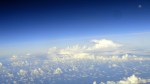
So I started thinking about all the clouds I’ve looked at from airplane windows the past two months. Figured I’d share some of them with you.
Trip one: late July (all the files are named yymmdd so you can tell which flight it was, and numbered in sequence, so if you think of the plane’s route, you can guess as I do roughly what we’re looking at – some landforms are obvious, others less so), the first time on a flight from PaP to Maimi that we went as far east as we did. Usually, the flights have passed just west of Ile la Tortue; this time the plane clearly diverted to the east, and I think it must have been to avoid a storm system: I think the first photo you see above is that storm system. Nothing like Matthew…but certainly on that day, flights were delayed all across North America due to storm systems, and we here had our little flight adjustments as well.


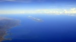
Trip two: the return leg from Miami to PaP, from the same vacation trip, in later August. I just love looking down at the islands, sandy bottoms and coral formations of the Bahamas. Then watching the shores of Haiti creep slowly closer and become landforms, towns and cities that I recognize and can place on a map.


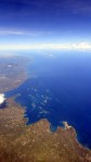
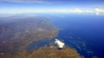
Trip three: from JFK down to PaP this time, leaving quite early in the morning on a clear Sunday. Saw the moon rise; saw rainbows in clouds as we approached a somewhat cloudy Haiti. Saw deforestation runoff coming into the bay near Port au Prince, and the bump of the Commune de Carrefour just west of downtown PaP. Saw the mountains to the south of downtown PaP, which I’ve explored a bit by car and on foot. Again – numbered in sequence from sitting on the runway at JFK, to a view at Jamaica Bay as we took off…and all the miles of ocean, clouds, moon and rainbows and bays and islands between.


Seven Views of the Golden Gate Bridge … Four of Twin Peaks


I’ve known the city of San Francisco for so long – from a childhood summer in Berkeley, from living in the city and/or staying for long period quite often in recent decades – that I tend to assume everyone is aware that it’s surrounded by water on three sides; that it’s full of hills which give beautiful views of its other hills, of the bay and the ocean that surround it, or of lovely San Bruno Mountain which draws up its southern border…that it’s full of beautiful Victorian houses nicely maintained and painted for the most part…that it is chock-a-block with parks at the tops of many those hills, giving thus even better views with greenery and flowers in the foreground, hills and Victorians n the background. But I realize, when I return to work and my international team of folks from Haiti and around the world, that my little corner of the world is one to which most people actually have not yet been. And so herewith some photos from lovely sunny days where I enjoyed the freedom to stroll at will and to pull out my camera any moment I felt like it. They’re all named in a way that intends to inform you of what you’re seeing. I hope you enjoy the photos as much as I enjoyed those strolls :-).


On the Road to Musical Adventures


 Two quite different views on two quite musical days: fairly typical vacation outing for me if I’m able to be around the Bay Area in August. I always look forward to the chance to hear some performances at the Cabrillo Music Festival, which my friends Gene & Howard introduced me two nearly two decades ago. This year I enjoyed two excellent evenings of contemporary music during the final season of their excellent long-standing conductor Marin Alsop. Day one, we drove down from SF via Route 1 for traffic reasons, and thus had far lovelier views and a chance to pick up fresh strawberries at a farm stand in the northern part of Santa Cruz county. I always enjoy that drive because so much of the west side of the peninsula and of Santa Cruz county remain very heavily agricultural, while of course the east side of the peninsula is silicon valley: economic (and visual) diversity, eh?
Day two we had a matinée performance of the contemporary Opera Powder Her Face produced by West Edge Opera in an abandoned train station right next to the freeway in Oakland. It must have been a very grand station before the rail lines were relocated to the north side of the major interstate that now runs right behind it. The opera was disturbing and quite well produced, and the train station made a great concert hall and interesting subject for architectural photography. I hope you’ll enjoy these glimpses of what I get up to given time and opportunity back home :-).


